-
Field Tested APRS Software!
PinPoint APRS offers a modern APRS solution with some of the best and unique features available in APRS software and it has been tested by a number of Amateur Radio Emergency Services (ARES) volunteers that use APRS during exercises and emergencies.
PinPoint APRS is completely free for individual use.
-
Loaded with Features!
PinPoint APRS has many unique features that are not found in any other APRS implementation and yet is very easy to use.
All features are easily accessible using configuration screens, menu selections or mouse clicks on a map.
What Is PinPoint APRS?
PinPoint APRS is free software that allows you to visually track and communicate with people using Amateur Radio (”Ham Radio”) equipment. During an emergency, it can be used as a location aware tactical communications tool. It is mostly used as a tool for tracking people and assets on a map, although it is capable of so much more.
During, for instance, a weather spotting event, an Incident Commander could visually track where spotters are deployed in the field, and direct them away from approaching weather using an area map on a computer screen.
PinPoint APRS was featured in the September 2018 issue of ARRL QST magazine.
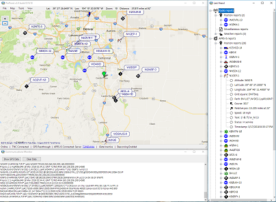
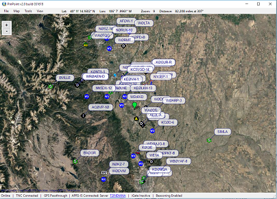
For a comprehensive overview of what APRS is capable of, take a look at the WikiPedia page. For a quick screenshot to see what PinPoint APRS looks like in action, click here.
PinPoint APRS does not require an Internet connection to operate (after you have cached all the maps and zoom levels you need) and is self contained. Many people use PinPoint APRS in their car, out in the field or in their homes. Click the Download button to go to the download page.
![]()
Quick Feature Overview
PinPoint APRS has a number of unique features not seen in any other APRS client implementation. Here's a quick overview of all features you will find in the latest version on the download page:
- Offline maps capability from many different types of map providers.
- NexRad Weather Radar overlay with animation (USA only).
- Weather Alerts polygons overlay & Alerts list including alerting when you're inside a warning area (USA only).
- Wildfire polygons overlay (USA only).
- GPX / KML / KMZ/ GeoJson file import and GPX / KML export of tracks, routes and waypoints.
- Ability to draw your own waypoints and tracks on the map and combine with imported GPX / KML / KMZ / GeoJson files.
- APRS Object support (point & click).
- Receive-only iGate.
- APRS-IS, TNC (KISS, TNC2), network TNC, NMEA GPS support.
- Full fledged APRS messaging client with auto answer capability when driving.
- Filtering of received stations based on (partial) call sign, path, tocall and/or APRS symbol to keep the map clean.
- Worldwide address search capability.
- Automatic reconnection to APRS-IS and network based TNC if you have spotty Internet or network connections (PinPoint APRS can run 100% offline too).
- Extended SSID support (> 15, letters, e.g. AB0WV-B, AB0WV-46) for APRS-IS and TNC's that support extended SSIS's (LoRa).
- Customizable visuals for APRS symbols, fonts, colors, tracks, etc.
- Easy to use with a friendly user Interface.
How Much Does It Cost?
PinPoint APRS itself is free software for individual non-commercial use. You don't need any radio equipment to start, and your needs just depend on what you would like to do. You need a valid FCC license (or the equivalent for your country) for the frequency you intend to use and a valid amateur radio call sign to use PinPoint APRS. A Donation is always appreciated, no matter the amount. See the Donation sidebar on the Download page for more info.
Active Development & Contact Info
PinPoint APRS is a labor of love by Frank, AB0WV, and is still under active development, so all the bugs may not have been worked out. If you have a great idea for a feature or are running into problems that are specific to PinPoint APRS (after you have exhausted the Quick Start guide and the FAQ page), feel free to send an email to ab0wv at arrl.net. If enough people suggest the feature you have in mind, it may be added to the product roadmap for PinPoint APRS. If you are sending a Bug Report, please take a look at the instructions on the download page first to ensure you're sending the details I need to be able to troubleshoot.
Built-in (Offline) Maps
PinPoint APRS has built-in mapping and supports quite a few different map providers, including Google maps, Bing maps, OpenStreetMaps, Carto maps, Stadia maps, ESRI and ArcGIS maps, USGS and more, including satellite and hybrid imagery. PinPoint APRS caches all map tiles that are requested from a map provider to ensure their tile servers are not used unnecessarily and allowing for offline use at the same time. Once maps are cached, PinPoint APRS can be taken offline, so it's perfect for use in rural areas where Internet access is unavailable.
What Do I Need?
Minimum requirements:
- The latest release of PinPoint APRS, which can be downloaded here.
- A desktop or laptop computer running Windows 7, 8, 10 or 11 with at least 4GB of RAM (better to have 8GB or more).
- Microsoft .NET framework 4.7.2 Runtime.
- Internet access, at least initially to cache the maps you need. Some features require Internet access.
- A valid Amateur Radio license from the FCC (or equivalent outside the USA).
Optional:
- An HF, VHF or UHF transceiver + power supply + antenna.
- A compatible TNC (Kantronics KPC/KAM, Kenwood or Yaesu APRS transceiver, serial or networked KISS TNC or TinyTrak4, SoundModem, VARA, etc.).
- Cables to hook everything together.
- A GPS with serial port NMEA output for mobile stations.